PORTLAND, Ore. – Zoning is a complicated subject, but even Portland residents who think they have an understanding of the residential zone they live in — R5, R2.5 and so forth — are often in for a surprise when land with this designation is divided into multiple parcels that would seem to be too small for its zone, and it’s all done legally.
At an increasing rate, underlying lot lines are being reopened and built upon most commonly by developers. This type of land use has been reported on by the Portland Chronicle in neighborhoods from Woodlawn to Beaumont-Wilshire to three recent cases in Eastmoreland.
An article on a demolition in Eastmoreland provides a detailed explanation of how underlying lot regulations work. A recent effort that has arisen in the form of a website calling itself “Fix Portland’s Zoning Code” has also detailed how underlying lots work and has offered some suggestions for how to reform those regulations.
But the exact scope of this issue and what it means for how Portlanders understand the zoning around them has not been publicized by any media outlet, until now.
A map sent to the Portland Chronicle contains all Portland tax lots and the underlying lot lines as of 2014.
View the map online or right-click that link to download the file. It is fairly large and very detailed, so it might take some time to load. Tax lots are presented in black and white, while underlying lot lines are displayed in orange. Viewers will need to zoom in quite close to see specific lots.
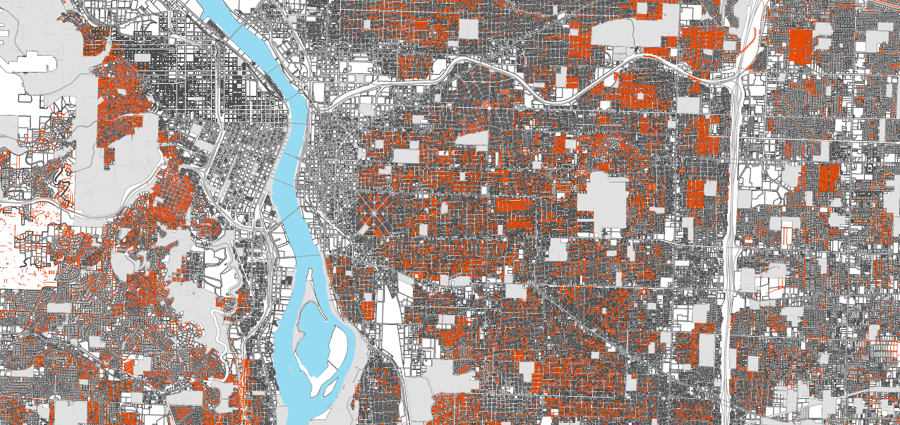
The map was created using a GIS shapefile obtained by the city. While it indicates where the underlying lot lines are located, it is not specific to the level of a survey and also does not contain street names or addresses. For specific address information PortlandMaps shows underlying lot lines in blue when the user zooms in at the maximum level on the explorer feature.

Underlying lots take different forms in neighborhoods around the city. In some areas, the lots of record line up with the current lots, “nested” within them and often bisecting them evenly. Many of the underlying lots are a result of the original 25- by 100-foot parcels being sold as 50- by 100-foot lots a century ago.
“Very, very few of these original lots were developed as 25-foot wide lots,” the map’s author, who asked to remain anonymous, explained. “And when this happened, what we would think of today as a ‘tiny house’ was developed — one story and no garage.”
Now, developers often look for lots that are 75 by 100 feet and contain multiple underlying lots of record. In the R5 zone, underlying lots must be a minimum of 3,000 square feet to be developed upon, so the standard 5,000-square-foot lot is too small for multiple units. A 7,500-square-foot lot allows for that land division.
In other areas, though, the issue becomes even more complicated as the underlying lots do not line up with the current configuration and are offset from the modern lot lines. An example was reported on by this publication in the Woodlawn neighborhood.
In these cases, only the property owner with more than half of the underlying lot on their property is able to utilize it for new development.
“This makes for a wild crazy-quilt of potential densities within a neighborhood … that is supposedly R5,” the source stated.
While underlying lots are present in areas citywide, they are certainly more prevalent in some areas, such as Concordia, Kenton and Eastmoreland.
“Some neighborhoods are much more heavily impacted than others,” the source said. “This is an invisible policy because it is buried in the code and maps such as the one I sent you aren’t readily available.”
The source posited that, given the extent of underlying lots and the frequent utilization of their development benefits by developers, zones should be appropriately named. If lots in an R5 zone (that most residents understand to be one residence per 5,000 square feet of land) are actually allowed one residence per 3,000 square feet of property, the source stated, they should be titled something along the lines of R3.
“We should know what to expect when we purchase a property or the city changes the regulations,” the source said.
While release of this information could potentially open the door for more utilization of underlying lots by developers, the source said that is likely to happen whether residents know about the lot lines or not.
“My sense is that (developers) already have this information and the rest of the public doesn’t,” the source stated.
To view the map, click here or right-click and save to download.